map-points.svg

Basic concepts

Key concepts:

The aCLIMAtar platform uses several concepts, which are outlined below. These concepts need to be understood to ensure the correct use of the tool.

A climate projection is the simulated response of the climate system under a scenario of future greenhouse gas (GHG) emissions or concentrations, usually derived from global climate models (GCM). A GCM is a representation of the climate system based on the physical, chemical and biological properties of its components, their interactions and feedback processes. Climate projections depend on the emissions scenario used, which in turn is based on assumptions regarding future socioeconomic and technological developments. GCM results have a resolution of approximately 100 or 200 km, which is not practical for assessing agricultural landscapes. Therefore, we use downscaled climate projections, interpolated at 5x5 km, which allows users to interpret the data at the district/municipality level. This approach relies on two key assumptions: first, that climatic changes vary only over large distances, and second, that the relationship between variables in the baseline remains valid in the future.

As for any future outlook, the models we use have a considerable degree of uncertainty and should be considered as projections of possible futures, not predictions. Climate projections are usually made by combining several independent models, to create a so-called ‘consensus’ model. GCMs currently available show a high level of agreement on an increase of temperature, but disagreement about the regional and seasonal distribution of precipitation (rainfall). The resulting consensus model of the independent projections is therefore, to a large degree, influenced by the temperature increase, while precipitation disagreement is masked (i.e., it can only be reflected to a certain extent in the final outcome). In our case, for example, we use floating bars to show the values ranges of different projections when show-casing future precipitation values.

Also, at least two major tendencies are important to bear in mind when discussing the impacts of climate change: change in mean values and change in frequency of extreme events (variability). A change in mean values shifts what is experienced as ‘normal’, an ‘extreme event’ or the ‘new extreme’. For example: for a given location formerly accustomed to a monthly mean temperature of 27°C, 30°C may become the new ‘normal’ temperature in summer, and what used to be considered extreme at 37°C is now surpassed frequently so that the ‘new extreme’ is found at 45°C, and so forth. When looking at the frequency of extreme events we need to look at climate variability. A change in frequency can mean, for example, that the same amount of monthly rainfall falls, but that it is now more often concentrated into two days instead of being spread throughout the month, leading to an increase in flooding and water erosion. For the combined change of means and variability see also Figure 1.

Our tool focusses on changes in means (i.e., ‘what is normal’). Mean changes in temperature (minimum, mean and maximum) and rainfall (monthly/yearly) can be modelled and displayed in quite a straightforward way and are included in our platform. However, changes in variability are not included yet, except for some of the climate hazard indicators that make specific reference to it.

Climate protection image
Figure 1: Future climates, when both mean and variance change, leading, for example, to a warmer, but also more variable climate.

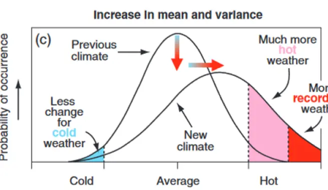
Source: Houghton JT et al., eds. (2001). Climate change 2001: the scientific basis. Contribution of Working Group I to the Third Assessment Report of the Intergovernmental Panel on Climate Change. Cambridge, Cambridge University Press. (Fig 2.32, to be found on p. 155). source link.

In the context of the aCLIMAtar platform, improving climate resilience and lowering climate vulnerability is the main pathway towards improving farmers’ livelihoods in the face of climate change. Thus, a climate-resilient farming system is one that can sustain its contribution to farmers’ livelihoods in times of climate change.

The farming system itself can be analysed by taking into account different dimensions of climate resilience, such as (c.f. Tendall et al. 2015.: robustness (capacity to withstand disturbance and maintaining functionality in situations of stress), increased resilience/flexibility or rapidity (recovering from shocks and returning to initial state and functioning of the system), as well as redundancy (possibility to fall back on alternatives). However, since resourcefulness (overall capital available in the system) can also contribute to climate resilience, we also embrace sustainable intensification within this concept and, in less suitable climate zones, non-farm income will be of growing importance.

It should be noted that climate adaptation — the process of building up climate resilience and lowering climate vulnerability — is an ongoing process, and a farm’s climate resilience will need to be reassessed as climate change advances.

Agro-climatic zones (ACZs) are a way of using climate data to classify crop-growing areas in different countries. ACZs are characterised as climatically suitable areas for cultivation, grouped according to similar characteristics such as humidity and temperature. In this line of thought, for example, cocoa-growing areas that share the same ACZ are characterised by similar (current) climatic conditions.

The classification of a region as an ACZ suitable for growing a given crop also takes into account this crop’s known distribution within the country of analysis and is complemented with additional expert advice. Then, based on a set of bioclimatic variables (WorldClim) and using a ‘Random Forests’ classification technique, the different ACZs are characterised and differentiated. Note: classification as suitable/unsuitable is based on the current, known distribution of the crop in the country. Thus, though highly unlikely, the crop may also be present in regions considered ‘unsuitable’, but will probably be far from its optimum performance under these conditions.

Changes between current and future distribution of the ACZs then determine the specific impact gradient and adaptation zone.

What differentiates agro- climatic zones (ACZs) from agro-ecological zones (AEZs)? Our system classifies ACZs based on climatic data interpreted specifically by crop, using known growing areas and expert knowledge. It is thus climate and crop specific. Meanwhile, AEZs can be defined as “Geographic areas with homogeneous sets of climatic parameters and natural resource characteristics, such as rainfall, solar radiation, soil types and soil qualities, which correspond to a level of agricultural potential.” IPBES (n.d. )IPBES In our analysis, expect for Ghana we do not include soil data.

We use the concept of adaptation zone and impact gradients to guide adaptation planning and action. Depending on the severity of climate change (‘impact gradient’), regions are classified as Incremental, Systemic, or Transformational adaptation zone (see Figure 2 below):

  • Incremental adaptation: these areas are likely to remain suitable in the future if Good Agricultural Practices are applied. We recommend strategically focussing on sustainable intensification to exploit the favourable climatic conditions for production. However, as climate impacts are likely to worsen in the future, in the mid- to long-term we also recommend building up climate resilience strategically.
  • Systemic adaptation: We expect these areas to remain suitable for farming the specific crop also in the future, but with considerable climatic stress that will require a comprehensive adaptation of the production system. This consideration is based on our current knowledge and that Good Agricultural Practices are applied. We recommend strategically focussing on building-up climate resilience and diversified income sources. As climate impacts are likely to worsen in the future, counting on diversified and climate resilient income sources will become increasingly important.
  • Transformational adaptation: For these areas and under current knowledge we expect that the increase in climate stress will make adaptation or a change of strategy indispensable. We recommend that priority be given to practices with high mitigation and adaptation potential, coupled with deep systemic change for diversification; i.e., gradually phasing-out the cash crop and transitioning to alternative livelihood sources.

Some areas might also be classified as ‘Opportunity’ zones; these are areas formerly not considered suitable for coffee/cocoa/tea farming, but that under climate change are predicted to become relatively favourable for their production. However, it must be noted that encroaching into these areas might put pressure on local ecosystems and expansion in these areas should be done with caution.

Adaptation class image
Figure 2: Recommended adaptation objectives for different time horizons described for each of the major adaptation zones.

Farmers have various levels of resources, such as time, money and labour, as well as different levels of understanding of climate change, which can impact their ability to adapt. To accommodate this, we offer distinct levels of practice recommendations ranging from basic to more advanced (in West-Africa: minimum, bronze, silver and gold. In East Africa: basic, advanced and premium). Some practices may only be suitable for more advanced farmers, so they will not be shown if you select a lower capacity level. However, you can choose several filters at once.

When deciding on which level to choose, you can think of the minimum or basic level as the bare minimum of what should be implemented within a practice category. This level may be chosen when looking for practices that would be suitable where resource constraints apply or knowledge on the practices is limited. For farmers who have more resources available or have already taken steps towards climate adaptation you can choose a more advanced level, beginning with bronze and silver / advanced and in certain contexts may even try to reach gold/premium. This will result in increasingly advanced practice recommendations, taking into account techniques that require higher skills/knowledge levels or greater financial investment, but also provide higher returns in productivity, resource efficiency and/or resilience.

Glossary:

Agro-climatic zones (ACZs) are a way of using climate data to classify the areas where crops are grown in different countries. ACZs are characterised as climatically suitable areas for cultivation, which are grouped according to similar bioclimatic variables. The classification also takes into account known distribution of the crop of interest, and within the specific country of analysis, and is complemented with additional expert validation. Then, based on a set of bioclimatic variablesWorldClim and using a ‘Random Forests’ classification technique, the different ACZs are characterised and differentiated.

Within the platform, we differentiate between different climate hazards to point out specific risks:

Crop risk:

  • High temperature/ Extreme temperatures: are abnormally high temperatures. Heat risk is calculated based on the number of days with daily maximum (air) temperatures above a threshold of 35°C, calculated for the whole year. As part of the general climate data shown, we also show average monthly maximum temperatures for past, current and future.
  • Heavy Rainfall: a period of abnormally high rainfall (either erratic or prolonged) and/or an overabundance of water resulting from this, which can lead to erosion, nutrient leaching and waterlogging or flooding. Heavy rainfall risk is calculated based on waterlogging days; i.e., days in which the soil moisture is above field capacity and moving toward saturation. Data is combined from precipitation data, temperature, solar radiation and soil data at 1 km grids.
  • Drought: a prolonged period of abnormally low rainfall and/or a shortage of water resulting from this. Drought is interrelated with the concept of prolonged dry season and changes in rainfall patterns. Drought risk is calculated based on the number of dry days (Precipitation < 1 mm) per month and per year, combining a yearly and a long-term mean.

Human risks:

  • High temperatures, especially when combined with high air humidity also pose a severe risk for humans, as our capacity to cool our body by sweating is restricted under conditions of high temperatures and/or humidity. We are then at risk of suffering heat related illnesses or even a heat stroke. Human Heat risk is calculated combining air temperature and relative humidity in shaded areas to compute a human-perceived equivalent temperature.

In the context of this platform, climate-smartness is understood as considering future climate projections when taking actions and making decisions in the present. Climate-smart practices tackle the climate challenges of a specific farming community, aiming to make farms more resilient to climate impacts they’re facing now, and those likely to hit in the future, while being embedded in a broader strategy on how to maintain current and future livelihoods.

Practices can contribute to climate resilience by enhancing one or several climate resilience dimensions of the farming system, such as robustness (capacity to withstand disturbance and maintain functionality in situations of stress), increased resilience/flexibility or rapidity (recovering from shocks and returning to an initial state and functionality of the system), as well as redundancy (the possibility to fall back on alternatives). Resourcefulness (overall capital available in the system) can also be considered, in addition to links to sustainable intensification. (c.f. Tendall et al. 2015)

The impact gradient is the climate-change severity projected for a particular region. According to the value of the impact gradient, regions will be classified as incremental, systemic or transformational adaptation zones. We differentiate between (i) incremental adaptation, where current and future ACZ remain the same; (ii) systemic adaptation, where the future ACZ is projected to differ from the current one; and (iii) transformational adaptation, where the future ACZ is classified as unsuitable for growing the specific crop.

In meteorology, precipitation is any form of hydrometeor that falls from the atmosphere and reaches the earth's surface. This phenomenon includes rain, drizzle, snow, sleet and hail.

Rainfall is a specific form of precipitation, where the hydrometeor falls as liquid water.

Temperature is one of the constituting elements of climate and refers to the degree of specific heat of the air at a given place and time, as well as to the temporal and spatial evolution of this element in the different climatic zones.

For more details, see the CCAFS climate-smart agriculture 101